Companion blog: Adventures In Stoving

Monday, November 26, 2012

Henninger Flats Camp

Last week, I climbed Newton Drury Peak, the "Last of the 10K's".   Newton Drury completed my climbing of all of the peaks over 10,000'/3048m in elevation in Southern California.

This week, I took on another challenge:  Backpacking with my young daughter.  Now, before you say there is no comparison, let me mention that she is three years old.  Not only must I carry all the gear for both of us, I usually wind up carrying her for the majority of the hike.  Gear + food + fuel + water for the two of us is somewhere around 40 to 45 lbs/18 to 20kg of weight for this time of year.  40 to 45lbs/18 to 20kg of weight is perfectly manageable for a person of my size, but now add the weight of my daughter  (~30lbs/13.5kg), and the total weight is about 70 to 75 lbs/32 to 34kg.  Now, that is a heavy load!

Naturally, with a load like that, I'm not going to take on a particularly aggressive hike.  For our destination, I chose Henninger Flats, which is about a 2.7 mile/4.3km hike (depending on which source you believe; some list it as 2.2mi/3.5km) with about 1500'/450m gain.  It's steep, but not undoable, and it's mercifully short.

So, let's get started.  The hike follows the route of the old Mt. Wilson Toll Road, a historic pathway into the local San Gabriel Mountains.  In days of old, one paid a toll in order to gain access to the road.  Today, the road is closed to all but official motor vehicles, but the road is free to all hikers, bicyclists, and equestrians.
On the Mt. Wilson Toll Road en route to Henninger Flats
The road is essentially shadeless, and the sun is unrelenting, so either get an early start or pick a cool day.  Note that the pedestrian gate at the start of the trail is locked from sunset to sunrise, so plan accordingly.

Our arrival at Henninger Flats is marked by this large sign.
Sign at Henninger Flats
A small notice posted on the sign warns that the water may not be safe to drink and recommends that one boil the water before consumption.  I've never had a problem with the water here, but use your best judgement.

Even though Henninger Flats is on the outskirts of the Angeles National Forest, it is operated by the County of Los Angeles.  It's not exactly a rugged wilderness camp, so hard core backpackers will want to look elsewhere, but for someone backpacking with a young child, it's a lovely, commodious facility. It's really more like a city park than a wilderness camp.

Here, I'm sitting with my daughter at one of the picnic tables.
Breakfast time in Henninger Flats
And what's on the menu for breakfast?  A muffin baked using a Bobcat System with an Epicurean Ti stove, both from Flat Cat Gear.  Fresh baked muffins are a real treat on the trail, and, best of all, my daughter will eat them.  My daughter is a little on the picky side and just won't eat things like powdered eggs.   When traveling with little ones, it's best in my experience to bring decent food.   Decent food prevents a lot of complaints and crying.  I'm not trying to spoil my daughter, but I find that my usual minimalist style of backpacking cooking just doesn't cut it.
A blueberry muffin, fresh baked out on the trail

Henninger Flats is graced with a number of large, mature trees which are perfect for stringing up a hammock.  Hammocks make great places for children to play.
My daughter, in a hammock at Henninger Flats
And, yes, those are my legs that she's sitting on.  How else do you think I got this angle?  :)
Child at play

Inevitably, though, children tire, and then we find another great use for a hammock:  nap time.
Sleeping daughter in a hammock

Speaking of sleep, sleep reminds me of night, and there's a real night time treat from Henninger Flats:  The view.
The San Gabriel Valley at night as seen from Henninger Flats

Downtown Los Angeles from Henninger Flats (long exposure, 15X zoom)
Greater Los Angeles from Henninger Flats

Alas, all good things must come to an end.
Sunset, seen while descending from Henninger Flats
But I have many sweet memories of a fine daddy - daughter time.
Iconic shadows seen while descending from Henninger Flats 

I thank you for joining me on another hiking adventure,

HJ

Wednesday, November 21, 2012

Newton Drury Peak -- Last of the 10K's

There are only 25 peaks in Southern California whose elevation exceeds 10,000 feet/3048 meters.  Over the years, I had climbed most of the more accessible peaks, leaving unclimbed only some of the more remote peaks.  A couple of years ago, I started more or less methodically climbing the remaining peaks.  In one of my September posts, I detailed my climb of Bighorn Mountain and the Dragon's Head.

As of November, 2012, only one 10,000'+ peak remained unclimbed:  Newton Drury Peak (10,160+ feet/3097+ meters) which is in the San Jacinto Mountains of Southern California.

The best route to Newton Drury Peak utilizes a combination of the Marion Mountain Trail, the Pacific Crest Trail (PCT), the Deer Springs Trail, and some cross country travel.  The trailhead for Newton Drury Peak is some two hours drive from my home.  To climb the peak, I'd have to ascend some 4000 vertical feet (1219 m) over about 4.5 miles/7.25 km.  The first 2.5 miles/4 km climbs an average of about 950' per mile (305m/km), which is quite steep.  The upper portion of the route is cross country (i.e. there is no trail).  Given the steepness and the cross country nature of the trip, I knew that this would be no quick ascent.  This time of year, there are only 11 hours of daylight.  Wanting to take full advantage all available daylight, I got up at 0310, got on the road at 0400, and arrived at the trailhead before dawn at about 0555.  I wasted no time in getting on the trail.

The day was cold and gray with intermittent rain and hail.
Fuller Ridge early in the morning as seen from the Marion Mountain Trail
A little more than a mile into the hike, one passes from the San Bernardino National Forest into Mount* San Jacinto State Park.  A wilderness permit is required for all travel in the wilderness portion of Mount San Jacinto State Park.
Sign marking the wilderness boundary
Notice in the photo above that there's a spot where a list regulations is meant to be posted.  The missing regulations are more or less indicative of the condition of the trail:  The trail doesn't receive much in the way of regular maintenance.  The trail does however receive a lot of use, so it's generally easy to follow.

As I ascended the Marion Mountain Trail, I began to encounter a few patches of old snow left over from a small storm that hit a week prior.  The fact that there was any snow left at all from such a small storm tells me that the nights have been pretty cold up on the mountain.
An old patch of snow near the trail
Now, I've said that the Marion Mountain Trail doesn't receive a lot of regular maintenance, and that's true, but in places one can see pieces of the original construction which show that a lot of time and effort were devoted to the making of this trail.
Stone work on the Marion Mountain Trail
Labor intensive stone work of this quality is undoubtedly a product of the Depression-era Civilian Conservation Corps, to whom all American hikers owe a debt of thanks.

Ascending further, we come to the junction with the Pacific Crest Trail which runs all the way from Mexico to Canada.
The junction of the Pacific Crest and Marion Mountain Trails
I was a little surprised that there was no indication of any kind that this was the Pacific Crest Trail (PCT).  The PCT is a major, national trail.  One would think that such a major trail would have some kind of sign, but apparently not.

The only indication that this was the PCT was a fallen over wooden post near the junction where there once had been a PCT symbol.
A wooden post that once had a PCT symbol on it.
Unfortunately PCT symbols are sought after as sort of a collectors item, and people pry them off the posts marking the route.   Because someone has stolen the marker off this post there's no indication that this is the PCT unless you happen to recognize that the indentation on the post is the same shape as a PCT symbol.

Shortly after joining the PCT, we encounter the junction with the Seven Pines Trail.
The signed junction of the PCT and the Seven Pines Trail
Once again there's nothing designating the main trail as the PCT although there is a PCT marker post set in the ground nearby.  Unfortunately, once again, someone has stolen the PCT symbol off the post.
Marker post on the PCT near the junction with the Seven Pines Trail
Next, we cross the one of the branches of the North Fork of the San Jacinto River in the area commonly known as Deer Springs.  There is typically water flowing in the creek, although in late summer/early fall, sometimes the creek does go dry.  There was water on the day I visited.
Water flowing at Deer Springs
Not only was there water, but also ice, again indicating cold nights.
Ice in the creek bed at Deer Springs
Just past the creek at Deer Springs, we come to the last trail junction on our route, the junction with the Fuller Ridge Trail.
Junction with the Fuller Ridge Trail
Again, there is no indication which trail is the PCT (The route of the PCT goes left here), and there is no indication as to what the trail to the right is (the trail to the right is the Deer Springs Trail).  There is however another marker post nearby, inscribed with a PCT symbol.  Unfortunately, the symbol is a little hard to read.
The very hard to read PCT symbol on a trail marker post.
The trails here aren't terribly confusing, so anyone with a decent map should have no trouble, still I was surprised that there were no signs indicating which trail was the PCT at all three junctions on my route.

Once past the junction with the Fuller Ridge Trail, we come to another branch of the north fork of the San Jacinto River.  This branch was also flowing on Friday, November 16, the day I passed by.  This is actually a fairly reliable source of water.  I've seen this branch have water when the branch by Deer Springs has been Dry.

Another branch of the N Fork of the San Jacinto River
Again, I encountered ice.
Ice at a branch of the N Fork of the San Jacinto River
There are a couple of other small water sources between this branch of the N Fork and Little Round Valley, and they were both flowing, albeit with low volume.

However, the creek that flows down out of Little Round Valley was completely dry at the trail crossing...
Dry creek bed below Little Round Valley
...and the creek was also completely dry in the meadow in Little Round Valley.
Dry creek bed in Little Round Valley
As poor as the signs were on the way in, I was surprised to see nice, new signs at all the campsites and marking the trail at Little Round Valley.
A new sign at Little Round Valley
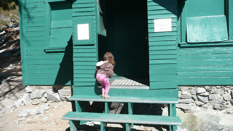
I also noticed that the old rickety outhouse at Little Round Valley (which frankly seemed quite precarious) has been replaced by a modern plastic outhouse.
New outhouse in Little Round Valley
I'm not sad at all to see the old outhouse go (it made me nervous to use the old one; it was so dilapidated), but I think this new plastic one is an eyesore.  Would that they had used an outhouse constructed of natural materials when they replaced the old outhouse.

Fires have long been banned in Mount San Jacinto State Park, but the fact is that people are still having them.
A campfire site in Little Round Valley
I have mixed feelings about wood fires, both pro and con, but one thing I will say for sure:  Please leave no trace.  If you're going to have a fire, you should do it in such a way that the next person to visit can't tell that you were ever there.
Another campfire site in Little Round Valley
Ringing your fire with rocks, although traditional, is simply not a good Leave No Trace practice.

Thus far, from the trailhead to Little Round Valley, the route has been fairly routine, on-trail travel.  From the camp sites in Little Round Valley, the route gets a little more interesting.  I needed to leave the trail, make my way to the south eastern head of Little Round Valley, proceed along an azimuth of about 120° true, and then angle southward, ascending to a saddle east of the peak at just over 10,000'/3048 m elevation.  The visibility on the day I went was fairly limited.  I would have to trust my map and compass.
A gray day on the flanks of Drury Peak
The terrain was somewhat steep and quite rocky, but I was able to thread my way through the rocks without undue difficulty.

Apparently, my route finding was fairly good that day, for I soon reached the summit block of Newton Drury Peak.
The summit block of Newton Drury Peak
The rocks looked intimidating, but by first going west and then cutting east, I was able to find a class one (no use of hands required) route.

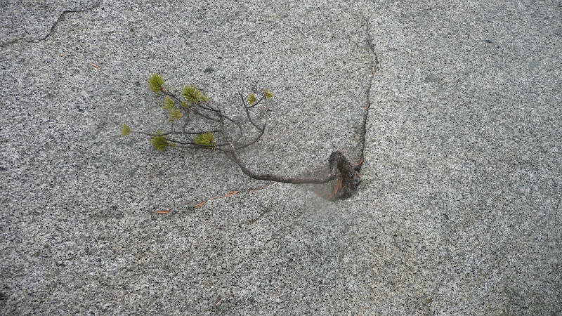
Passing through the rocks, I marveled at the tenacity of the plant life that holds on in the extreme conditions found here on the mountain top.  What a remarkable little tree!
A very tough little Lodgepole pine (Pinus contorta), high on Newton Drury Peak
After threading the rock maze, I went directly up a few final slabs and attained the summit.
Final slabs en route to the summit of Newton Drury Peak
On the summit, there were some really beautiful examples of krummholz ("bent wood"), trees gnarled by the extreme elements.
A krummholz tree atop Newton Drury Peak
Having attained the summit, I decided to take care of another matter on my agenda:  Lunch.  I pulled out my Bobcat stove system and boiled up a little water for a nice chicken and noodles lunch.
Lunch spot, summit of Newton Drury Peak
The wind was blowing so hard that I had to weight down the carbon felt insulation on the pot lid to keep it from flapping.
Weighting down things against the wind atop Newton Drury Peak
It was a cold day atop the peak.  Frost was forming on my mittens.
Frost on my mittens.
There may well be a good view from Newton Drury Peak, but I had no idea that day.  I had to content myself with the wind swept trees and gray clouds.
Gnarled trees atop Newton Drury Peak
Having attained the peak, the last of the 10K peaks in Southern California for me to climb, I turned for home.   My goal was to reach my car before full dark, but unfortunately, night fell while I was still on the trail.

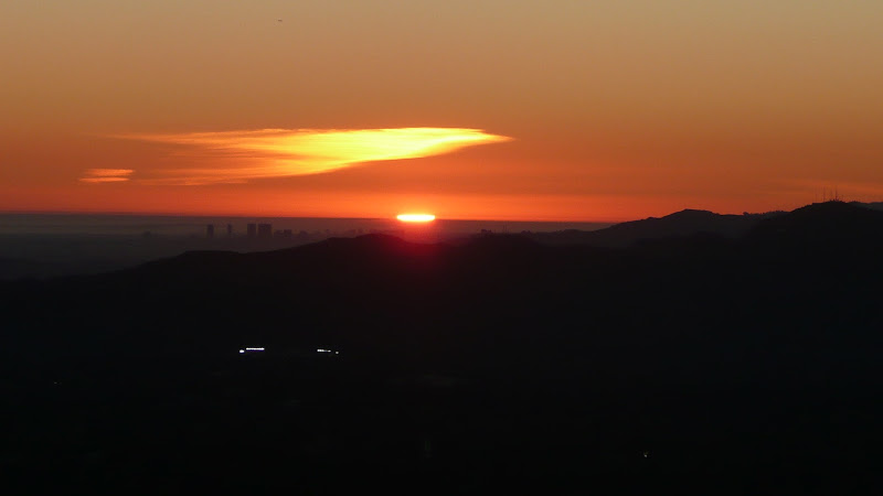
I did, however, get some nice sunset shots from the Marion Mountain Trail.
The Sun setting above Diamond Valley Lake
Sunset and Diamond Valley Lake
Fortunately, there was a little bit of a moon out that night, and I was able to complete the hike without even using my head lamp.  I completed my hike without further ado, and drove home.
The moon as seen from the Marion Mountain Trail
I thank you for joining me on another hiking adventure,

HJ

*The correct name for the highest point in the San Jacinto Mountains San Jacinto Peak, but some genius named the state park Mount San Jacinto, and there's been nothing but confusion ever since.  Indeed, the sign atop the peak reads "Mount San Jacinto Peak" a bastardization combining both the mistake and the proper name.  Bureaucracy at it's finest.

Monday, October 15, 2012

San Antonio Ski Hut

It was a beautiful fall day this past Saturday, a great day for a hike.  But where to go?  Well today I thought I'd head up to historic San Antonio Ski Hut built on the flanks of Mount San Antonio (10,064'/3068m) by the Sierra Club in 1937.
Historic San Antonio Ski Hut

Our journey starts at the trailhead on Mount Baldy Road in Manker Flat, just north of the town of Mount Baldy.  A word on nomenclature:  The official name of the highest peak in Los Angeles County is Mount San Antonio, but nearly everyone calls it "Mount Baldy."  When seen from a distance, particularly when snow-capped in the winter, the mountain does indeed appear to be "bald" (devoid of trees) when compared to the surrounding peaks.

The first part of the hike follows a paved road, suitable for all, including very young hikers.  I've quite literally seen people pushing baby strollers (perambulators) up the road.  This road, if followed all the way, goes to the downhill ski area at Baldy Notch.  Note:  The San Antonio Ski Hut is in a completely different area of the mountain than the commercial downhill ski area at Baldy Notch.
Ascending the paved road from Manker Flat

At the first major turn in the road, we're treated to this, a view of lovely San Antonio Falls.
San Antonio Falls, upper tier
San Antonio Falls, lower tier

San Antonio Falls is quite popular with canyoneers.
A canyoneer descending San Antonio Falls

After the first major bend, the road turns to dirt.  As one ascends, one comes to a junction with a trail that heads up hill to the left.  This is our route.
Junction of the trail to the ski hut (left) and the Baldy Notch road

The trail to the ski hut and the summit of Mount Blady that splits off from the Baldy Notch road is well signed...
Trail sign on the trail to the ski hut and the summit of Mount Baldy
...but the sign could be a bit misleading.  The trail with the name "Mount Baldy Trail" is of course another trail, the trail that goes from Mount Baldy village to the summit by way of Bear Flats.  This trail to the ski hut doesn't have an official name in the eyes of the USGS but is most commonly known as the "Ski Hut Trail" or the "Baldy Bowl Trail".  Perhaps the sign should read "Trail to Mt. Baldy" which sounds less like a name.

Soon after leaving the Baldy Notch road, one comes to a trail register.  It's been a while since my name has appeared in that register, and my daughter has never appeared in that register.  We quickly signed in, and...
Our names in the trail register en route to the ski hut
...I can now emphatically state that my daughter has appeared in that register!
Trail register en route to the ski hut and the summit of Mount Baldy

Shortly thereafter, one rounds the shoulder of a ridge, and one gets one's first look at the ski hut which appears deceptively close (particularly on maximum zoom on my camera).
San Antonio Ski Hut, zoomed in

The reality is that you've got a couple of miles (3km) and about 1400' (425m) of gain yet to go.
San Antonio Ski Hut, zoomed out

This little ridge is also an alternate route to the summit of Mount San Antonio.  In years past, the route was a true cross country route.  Now, the route has become so popular that a use trail has developed.
Junction of the Ski Hut Trail and the Register Ridge "Trail"

Looking back to the south, one starts to get some nice views of Ontario Peak and The Sugarloaf.  These views continue to improve as one ascends.
Ontario Peak (skylined) and The Sugarloaf (small peak in front of Ontario Peak)
The Sugarloaf

As one ascends further, Telegraph Peak begins to come into view.  The views to the east from the summit of Telegraph Peak are spectacular.
Telegraph Peak

The trail is in good shape and easily passable for the most part.  It's clear that recent significant maintenance has been done, perhaps by that most esteemed of groups, the San Gabriel Mountains Trailbuilders, to whom all who pass here owe a debt of thanks.
Signs of recent (and very professional) trail maintenance

There are still three or four spots where the trail passes over rocks that might be somewhat difficult for backpackers carrying a full overnight pack or day hikers carrying a child.  I found myself glad to have trekking poles.

Climbing higher, we get better views of the Baldy Bowl.
The Baldy Bowl

The skiing in the bowl is excellent in season with many challenging chutes dropping in from the ridges above.  It is this bowl that inspired the construction by the Sierra Club in 1937 of San Antonio Ski Hut that sits just below the bowl.

As we approach the ski hut, the views get better still.  We can now see Cucamonga Peak, and if one looks closely, Bighorn Peak can be distinguished in front of Cucamonga Peak.
Cucamonga Peak (center, skyline) with Bighorn Peak just in front

We also come to some water, still running even now in late season.  
Water flowing just before the ski hut

There are three sources of water in and around the ski hut.  I've listed the details of that water in this companion post:  Water Sources at the Ski Hut

Looking up from the water, we see that we're nearly at our destination, the ski hut.
San Antonio Ski Hut, seen from just below

Also looking up from that seemingly tempting water, we see an outhouse.  
Ski hut (left) and outhouse (right)
Um, maybe you might want to check out that companion post of mine on water sources before you drink.  

Interestingly, I note that our historic ski hut from the 1930's has had some high tech upgrades.
Solar panels on the ski hut's roof
Presumably these solar panels provide power for lighting or perhaps even ventilation.

From the vicinity of the ski hut, one gets a better view of Telegraph Peak.  
Telegraph Peak (the leftmost summit)
In front of Telegraph Peak, one can see part of what appears to be one of the ski runs on Thunder Mountain.

Looking up, we get more views into the Baldy Bowl and the terrain that has lured skiers and winter mountaineers here over the years.
Looking up into Baldy Bowl

At long last, we arrive at the ski hut itself.
San Antonio Ski Hut as seen from the west
Estimates vary as to the length of the trip.  Tom Harrison lists the mileages at 0.9 miles from the trailhead in Manker Flats to the junction where the Ski Hut Trail takes off and 3.3 miles from the junction to the hut for a total of 4.2 miles one way.

The Sierra Club has been good stewards of the site, and there are many nice appointments in and around the hut such as this rustic log bench, which is quite popular with weary passers by as I'm sure you can imagine.
A most inviting spot to sit near the ski hut

There's also this one small picnic table with rustic seating, a perfect spot for a picnic.
A lovely spot for a little picnic

Looking around, we see that there are challenges aplenty for those inclined to the extreme, such as these pinnacles.
Pinnacles above Baldy Bowl

For those less extreme, there is still much to like.  My daughter found the front steps and entry of the hut to be a source of endless fascination.
The front steps of the ski hut

Of course, one could simply just take in the view.
The view to the south from San Antonio Ski Hut

So, whether your pursuits are extreme or prosaic, the ski hut is nice destination in a lovely setting.
The enchanting environs of the ski hut

Well, that's it for today's journey; time to head for home.
Descending from the ski hut

I thank you for joining me on a trip to the San Antonio Ski Hut on the slopes of Mount Baldy.

HJ