Sometimes I like to take the whole family out for a hike. The problem is that I have to "tone it down" a bit so that everyone enjoys it. My wife, for one, just isn't going to put up with some of the longer, harder hikes I might do on my own. But where to go?
Well, this past weekend, we went out to Lower Fish Creek near the San Gorgonio Wilderness. One of the nice things about this hike is that it's outside of the wilderness which means you don't have to stop to get a permit or worry whether or not all the permits have already been taken.
Also nice is the fact that it's a semi-loop. I say "semi" because you enter and leave via the same trail but there's a nice loop at the far end of the hike. Take a look at the below map, and I think you'll see what I mean. I've highlighted the route in yellow. Click to enlarge. Note that there you can go beyond the route that I've highlighted on the map. I'll say more about extended day hiking and backpacking options in the appendix.
 |
| The Lower Fish Creek Loop hike. Click to enlarge. |
The hike is about 4 miles (6.5 km) round trip, and there's about 500 feet (150m) of gain. At our "blistering" pace, we did it in about 4 hours. A fit hiker could probably do that in half that time, but for families, allow about 5 hours.
The hike starts at the Lost Creek trail head. One parks across (on the north side) of highway 38, opposite the entrance to South Fork Campground and starts on the Santa Ana River Trail (2E03). The trail uses an underpass to cross the highway although traffic isn't typically so heavy that you'd need to use it; I leave that up to you, the reader. If you take the underpass, it's pretty easy to stay on the trial. If you just cross the highway, you have to look for the trail heading right (west) before you enter the campground proper. Periodically, you'll see signs with the trail number on them.
 |
| Trail 2E03 (Santa Ana River Trail) |
The trail first heads west and then joins an old road and turns east. You'll soon come to the junction with the Lost Creek Trail (1E09), but don't turn here, go straight (east), staying level.
 |
| Junction with the Lost Creek Trail |
You'll soon come to Lost Creek itself, which you'll have to cross. In early season in wet years, you may get wet crossing the creek. In drier years or in late season, usually it's no problem to cross the creek on rocks. Here, a backpacker crosses the creek just ahead of me.
 |
| A backpacker crossing Lost Creek |
Right after you cross the main branch of Lost Creek, you'll soon come to another, lesser branch (usually dry). You'll see a road coming in from the left. There are some old cabins along this road. You continue straight to stay on the Santa Ana River Trail.
OK, now here comes the hard part, so
pay attention. Do you see the junction I've circled in
red on the map? This is the trickiest part of the whole trip. The old road that you've been following goes straight, into "College Camp" (which I think was once affiliated with UCLA). The Santa Ana River Trail heads right. It's not at all well marked. There's no sign. You just have to be looking for it. What appears to be the main track heads straight. You're going to want to go straight, but you just have to bear right at this point. If you get into a camp with buildings and such, simply retrace your steps back to this junction – and then take the other fork.
 |
| The unmarked junction. The Santa Ana River Trail bears right here. |
Now, you're going to contour along above College Camp for a while after which you'll descend into lovely Fish Creek.
 |
| The old road that is now the Santa Ana River Trail (2E03) descending into Fish Creek. |
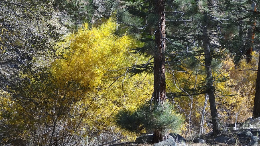
Fish Creek is a great spot. We hit the creek in late October. The best fall colors are around the first or second weekend of October, but still the willows did not disappoint.
 |
| Willows in fall splendor along Fish Creek |
The cottonwoods too played their part.
 |
| Cottonwoods at Fish Creek |
And the Black Oaks were no less well adorned.
 |
| A black oak in fall color and a young hiker. |
Soon, you'll need to cross Fish Creek, but this is no problem. A section of an old log has been emplaced and the crossing is easy.
 |
| Creek Crossing on the Santa Ana River Trail, Fish Creek |
In fact, it's pretty easy even if you're carrying a big load or ...
 |
| The author and his daughter, crossing Fish Creek |
... you're a little hiker.
 |
| The author's daughter, crossing Fish Creek. Easy. |
Now, pay attention again. Shortly after the stream crossing, you're going to come to an unmarked junction. Here, I'm looking at the junction from the east.
 |
| Unmarked junction in Fish Creek. |
The nice part about this junction is that there are no wrong answers. :) Seriously, recall that we're doing a loop. You can go either direction. However, navigation is easier if you go
straight, i.e. if you continue up Fish Creek. Note that on the topo map I included above there is not trail marked as going up Fish Creek. This is incorrect. There is a good trail all the way up Fish Creek. I've shown the approximate route of the trail with the bright green colored dotted line.
The trail goes through this distinctive cut in this large old log. In the photo below, my wife is standing at the junction. The distinctive cut in the old log is clearly visible from the junction.
 |
| The trail heading up Fish Creek |
Now, I've mentioned that the trail isn't marked on the official maps. As a consequence, the trail doesn't appear to be getting much maintenance. There were some downed trees like this one, below. No big deal (simply walk around), but be aware that maintenance is infrequent and informal. Still, it's a good trail and worth your time. It's getting plenty of use judging by how well worn the tread is.
 |
| Down tree, lower Fish Creek Trail |
Soon, you'll come to another crossing of Fish Creek. Again, the crossing is pretty easy although in early season in wet years, it may be more of a challenge.
 |
| Second crossing of Fish Creek |
On the far side of this crossing, you'll soon enter an interesting area full of equisetum ("horse tail" reed).
 |
| Equisetum and gooseberry along the lower Fish Creek Trail |
Soon after, you'll climb a bit and join a barely recognizable old road bed.
 |
| Climbing up to the old road bed. |
You'll follow the old road bed until it crosses the creek. The creek is narrower here and as a consequence, a bit deeper. This might be the trickiest of the crossings, but there are rocks in place, and it's not big deal for adults. Little hikers will need a hand with this one.
 |
| Third Crossing in Fish Creek |
Shortly after the crossing, you'll come to a junction which is signed only as "trail".
 |
| Trail junction just beyond the third crossing |
There are two signs. The sign farthest upstream points out the route if you were to continue up Fish Creek. The lower Fish Creek Trail goes all the way up to Aspen Grove.
 |
| The upstream sign points out the continuation of the lower Fish Creek Trail |
Our route today heads away from the creek at this junction and follows the old road bed.
 |
| The old road bed on the far side of Fish Creek |
Erosion and the years have taken their toll on the old road bed. It's no longer truly a road, but it's a fine trail. Some years ago, when I took this path, it was fairly faint. Evidently, a lot of people have discovered this route for it's now a clear, well-worn path.
 |
| The path climbing out of Fish Creek |
When you reach the top of the gorge of Fish Creek, the path is a little less distinct, but still quite followable. You're basically following the old road bed. Note that on the topo map the road is shown as just abruptly stopping. Uh, no. The old road road bed continues and joins the other roads shown to the east.
 |
| Following the trail/old road bed on the far side (east side) of Fish Creek |
You're now walking through some lovely woods, woods made all the more lovely by splashes of fall color.
 |
| Woods and fall color. |
If you look sharp, you can see bits of the history of the area, reminders that this was indeed once a road.
 |
| What appears to be an old gas tank or some other paraphernalia from a motor vehicle |
Again, if you look sharp, you can see an old sign post at approximately the point where the road up Fish Creek joins the road coming up from the Heart Bar area (1N39A). This road is very faint. You can follow it, but I recommend that you continue a bit further east until you join the Santa Ana River Trail (2E03).
 |
| Road 1N39A (what's left of it). Not recommended for family outings. |
Soon you'll come to the more or less unsigned junction with the Santa Ana River trail (2E03). In the photo below, I'm standing just east of the junction. The left branch (blocked off) is the old road that leads to Fish Creek. The right is the Santa Ana River Trail. Note the trail sign which says "2E03" on the right. It's not really a sign marking the junction; it's just marking the trail, but it's helpfully located, so take note of it.
 |
| Unsigned junction of the road from Fish Creek with the Santa Ana River Trail. |
At this junction, you'll want to head back west on the Santa Ana River Trail. Just west of this junction, there's a downed tree. This is a maintained trail, but apparently they just haven't gotten to this one.
 |
| Downed tree, Santa Ana River Trail |
Soon you'll re-cross the remains of road 1N39A. It's pretty distinctive where it heads down to the river.
 |
| Road 1N39A heading steeply down to the Santa Ana River |
I'll say more about this section of road in the appendix. On the uphill side, you can barely make out where the road used to run. It's followable if you look closely, and it will lead you to the road coming up from Fish Creek.
 |
| Looking straight down the remains of road 1N39A |
Soon after passing old road 1N39A, the trail takes a switch back left and you descend to Fish Creek.
 |
| Descending from the east on the Santa Ana River Trail into Fish Creek |
As you descend into Fish Creek, you should be first heading almost due south. The trial as it nears the bottom will turn more westerly.
 |
| Nearing the bottom of Fish Creek. |
At the bottom of the descent, you should be at the junction that you passed through on your way in. If you look left, you should again see the distinctive cut in the old log.
 |
| The distinctive log cut on the lower Fish Creek Trail |
At this junction, you want to turn
right and head down stream. You do NOT want to go back through the distinctive log cut. Assuming you didn't go back through the cut log, you're now back on the trail that you came in on. Simply follow your original path back to the Lost Creek Trailhead where you parked your car.
Thanks for "joining" me on this loop hike through the lower section of Fish Creek. I hope you find this trip report/trail guide helpful.
HJ
Appendix – Other Hiking Options
If you can read maps well, you'll no doubt see many other hiking and even backpacking options in the vicinity. I'll make a few remarks below that you might find helpful.
I. Backpacking
Now, I've made mention that the lower Fish Creek Trail goes all the way to Aspen Grove, and indeed it does. For some reason the topo map from the USGS shows the trail abruptly ending just north of hill 7210. This is not correct. The trail is a through trail. Given that this is a through trail, this leads us to an interesting backpacking possibility, what I call the Grinnell Mountain Loop. I've marked the loop on the below topo map. You'll want to click on the map to zoom in. You can make it a two day hike, staying at Dry Lake or Lodgepole camps, or you can make it a three day hike staying at Fish Creek Camp the first day and Grinnell Ridge Camp the second. Grinnell Ridge Camp is a neat spot and is far less visited than many of the other camps in the wilderness. I recommend it. Note that there are several sections where the topo map does not show a trail, but rest assured there is decent trail all the way.
 |
| The Grinnell Mountain Loop |
II. Longer Day Hikes
Here, I'm going to refer to the original map that I posted.
|
| The Lower Fish Creek area. Click to enlarge. |
Option A, Aspen Grove. As noted above, the lower Fish Creek Trail is a through trail. The lower Fish Creek Trail goes all the way to Aspen Grove (and beyond). For those who would like to visit Aspen Grove and would like either a) to avoid the dirt road or b) have a bit more of a hike, the Lost Creek Trailhead offers an a nice alternative to the Aspen Grove Trailhead. Note however that the portion of trail blotted out with red "X's" on my map, above, really isn't there anymore. You can find parts of it if you look hard, but it's really not a followable trail anymore (it was a road at one time). Your best bet, if you want to connect to the Aspen Grove trailhead, is to hike the lower Fish Creek Trail to the Wildeness Sign (see below) and take the main trail to the Aspen Grove trailhead from there.
 |
| The author at the Wilderness boundary sign on the main trail from the Aspen Grove trailhead. |
Option B, a longer Lower Fish Creek Loop. Note road 1N39A which runs from the Heart Bar area. I've circled the northern end in an aqua color. I've taken this road from the Heart Bar area. It's really hard to find the start of the road and where the road crosses the river. It's very overgrown. I didn't find that route particularly worthwhile.
However, if you go further along the road, you'll see where it leaves Santa Ana River Trail (circled in purple) and where it joins the lower Fish Creek trail (also circled in purple). One could take a nice loop hike, similar to the loop hike described in the main body of this post, but instead of using the route highlighted in the above map, use road 1N39A to complete the loop. Note that road 1N39A is in somewhat rough shape. There were downed logs over the road and not a lot of signs of use when last I travelled the road. Both ends of this section of the road are a bit tricky to find. I'll describe here how to find the northern end (circled in purple) where it leaves the Santa Ana River Trail (2E03).
Just east of the unsigned junction of 2E03 with 1N39A that is described in the main body of this post, the old road climbs slightly. I apologize for the poor photo quality, but here's what it looks like. You're clearly on an old road bed here.
 |
| Road 1N39A/Trail 2E03 (they're one at this point) climbing slightly. |
The trail is going to veer slightly to the left as seen below. Do you see the stump over to the right in the distance at the tree line. That's the road. The road switch backs hard right at the stump. Once you get to the stump, the road is easy to follow, but the first 100 yards/100 meters or so is tricky to find.
 |
| Trail 2E03 veering left slightly as it leaves the old road bed of Road 1N39A. |
You can more or less see the outline of the old road bed if you look closely, but it's not distinct. You just have to be looking for where the trail leaves the road bed and veers a bit left and goes downhill. You can kind of see the outline of the road in the photo below. Note again that stump, here just slightly left of center. Head for the stump.
 |
| The outline of the old road bed veering right from the trail. |
Right at the point where the road leaves the trail, there is a somewhat worn "2E03" trail sign.
 |
| A trail sign at the point where the old road leaves the trail |
This old road (1N39A) is an interesting variant of the shorter loop that I described in my main post (above). As I mentioned, it's in rougher shape, so I'd say this is for either adults or older kids.
I'm sure you can think of additional variations in this area on your own, but I hope you find my trail notes helpful.
HJ


No comments:
Post a Comment