Here, I will describe the principal route to Antsell Rock, the "Sam Fink route" (named for its discoverer) which proceeds from the Pacific Crest Trail (PCT) along the north ridge of Antsell Rock.
 |
| Antsell Rock from the north saddle |
Antsell Rock is just that, a rock, and to ascend it, one must do a bit of class three rock climbing. See the Yosemite Decimal System (YDS) if you're not familiar with the different classes.
A few words on the route and safety: The route up Antsell Rock involves some exposure, exposure being a climber's term for terrain where long, uninterrupted falls are possible. Hopefully the following photos will illustrate the distance one could potentially fall on this route. A fall on this route could be quite serious or even fatal. While this is not a technical climbing route, good safety practices should be observed at all times. It is up to you to learn what safety practices are appropriate for this route and to assess whether or not the risk associated with this route is acceptable to you and whether or not you have the skills and experience necessary to complete the route safely. You should also be comfortable with route finding and land navigation. Getting off route when climbing Antsell Rock could turn a fun adventure into a day of tragedy. Generally, Antsell Rock is not appropriate for newcomers to the back country, off trail travel, and rock climbing. That said, Antsell Rock is a great adventure for hikers well versed in rough terrain and class three rock travel. Enough on safety, but do think before you head out.
Please note that the Mountain Fire of July 2013 affected much of this area. Check on trail conditions and area closures before you plan a trip to this area.
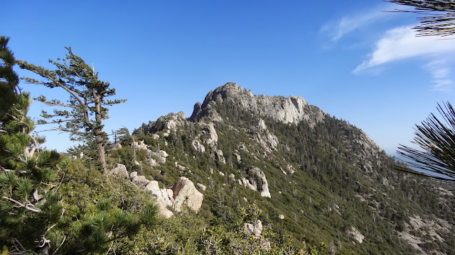
Not only is there the climb of the rock itself, but the approach to the base of the rock requires a good bit of route finding, rock climbing, and bush whacking.
 |
| The route to Antsell Rock |
The ridge approach from the north alternates between brush and rock. There's a lot of up and down and reversing to get around obstacles. The route through the brush and rocks is not obvious. Think obstacle course, not trail. There are "ducks" (stacks of rocks) placed periodically that indicate the route, but the ducks are few and far between and are generally insufficient to adequately mark the route. I got off route multiple times.
 |
| En route to Antsell Rock along the north ridge |
Be prepared to do your own route finding -- and to have to reverse course when you come to an impasse.
 |
| Downclimbing an obstacle en route to the base of Antsell Rock |
On both the approach and the return, one generally should stay on the west side of the ridge. The east side is quite steep.
 |
| The very steep east face of the north ridge of Antsell Rock |
As one approaches the rock, one begins to get a sense of the true scale of this massive rock.
 |
| Approaching the base of massive Antsell Rock |
Staying on route is important because you need to get to this, a crack in the north face of Antsell Rock. This crack affords one access to a class 3 route to the summit. Other routes traverse class 4 or class 5 terrain. Note the distinctive bonsai like tree by which the correct crack can be distinguished. This crack is behind a boulder at the apex of the shoulder of the north ridge of Antsell Rock, right where the ridge connects to the rock.
 |
| This class three crack gives one access to the summit of Antsell Rock |
At the top of the crack, one reaches this chockstone, but it's fairly easily surmounted either to the left or right.
 |
| Chockstone at the top of the class three crack on the north ridge of Antsell Rock |
Above the chockstone, one encounters a fairly smooth rock rib. There's no class three route up this rib.
 |
| Rock rib above the chockstone |
At this point, traverse to your right along some ledges past a dead pine into a brush choked gully.
 |
| Traverse right from the rock rib along some ledges past the above seen dead pine |
Then ascend the brush choked gully until you reach the head of the gully.
 |
| Brush choked gully beyond the traversing ledges |
 |
| Looking back down the brush choked gully. |
At the head of the gully, go left up this crack.
 |
| Crack leading left at the head of the brush filled gully |
After climbing to the top of the crack in the red rocks, traverse climber's left along the face until the grade decreases.
 |
| Beyond the left leading crack, traverse climbers left below the above shown face |
When you reach a point where the grade decreases a bit, scramble steeply up the mix of gray and red rocks to the summit.
 |
| Ascend at a point where the grade lessens a bit |
Though the grade is not overly steep here, a stumble here would have serious consequences. Care must be taken with the placement of hands and feet.
 |
| Looking down while scrambling up the last bit to the summit of Antsell Rock |
At last, one reaches the fairly small but relatively flat summit of Antsell rock which is marked with a small aluminum pole.
 |
| The summit of Antsell Rock. Note the red shade of the rock on the summit. |
While the approach took me about an hour, the ascent of the rock itself only took about 20 to 25 minutes. I took a moment to sign the summit register.
 |
| Summit register entry, Antsell Rock |
The views from the summit are quite good.
 |
| West ridge of Antsell Rock. Garner Valley in background. |
Descend the way you came. Take care when returning to the brush choked gully. The descent is steep and a bit loose.
 |
| Descending again to the brush choked gully |
Take particular care to leave the brush choked gully at the same point you entered. Getting off route here would lead you into some very steep, loose terrain. The dead pine serves as a good route marker.
 |
| Heading back to the rock rib from the brush choked gully. Note distinctive dead pine on the left. |
Congratulations! You've just completed a climb of Antsell Rock, the most interesting and challenging peak on the Desert Divide in the San Jacinto Mountains.
 |
| Antsell Rock |
I hope you get a chance to put these directions to good use.
Thanks for joining me,
HJ