Companion blog: Adventures In Stoving

Monday, October 15, 2012

San Antonio Ski Hut

It was a beautiful fall day this past Saturday, a great day for a hike.  But where to go?  Well today I thought I'd head up to historic San Antonio Ski Hut built on the flanks of Mount San Antonio (10,064'/3068m) by the Sierra Club in 1937.
Historic San Antonio Ski Hut

Our journey starts at the trailhead on Mount Baldy Road in Manker Flat, just north of the town of Mount Baldy.  A word on nomenclature:  The official name of the highest peak in Los Angeles County is Mount San Antonio, but nearly everyone calls it "Mount Baldy."  When seen from a distance, particularly when snow-capped in the winter, the mountain does indeed appear to be "bald" (devoid of trees) when compared to the surrounding peaks.

The first part of the hike follows a paved road, suitable for all, including very young hikers.  I've quite literally seen people pushing baby strollers (perambulators) up the road.  This road, if followed all the way, goes to the downhill ski area at Baldy Notch.  Note:  The San Antonio Ski Hut is in a completely different area of the mountain than the commercial downhill ski area at Baldy Notch.
Ascending the paved road from Manker Flat

At the first major turn in the road, we're treated to this, a view of lovely San Antonio Falls.
San Antonio Falls, upper tier
San Antonio Falls, lower tier

San Antonio Falls is quite popular with canyoneers.
A canyoneer descending San Antonio Falls

After the first major bend, the road turns to dirt.  As one ascends, one comes to a junction with a trail that heads up hill to the left.  This is our route.
Junction of the trail to the ski hut (left) and the Baldy Notch road

The trail to the ski hut and the summit of Mount Blady that splits off from the Baldy Notch road is well signed...
Trail sign on the trail to the ski hut and the summit of Mount Baldy
...but the sign could be a bit misleading.  The trail with the name "Mount Baldy Trail" is of course another trail, the trail that goes from Mount Baldy village to the summit by way of Bear Flats.  This trail to the ski hut doesn't have an official name in the eyes of the USGS but is most commonly known as the "Ski Hut Trail" or the "Baldy Bowl Trail".  Perhaps the sign should read "Trail to Mt. Baldy" which sounds less like a name.

Soon after leaving the Baldy Notch road, one comes to a trail register.  It's been a while since my name has appeared in that register, and my daughter has never appeared in that register.  We quickly signed in, and...
Our names in the trail register en route to the ski hut
...I can now emphatically state that my daughter has appeared in that register!
Trail register en route to the ski hut and the summit of Mount Baldy

Shortly thereafter, one rounds the shoulder of a ridge, and one gets one's first look at the ski hut which appears deceptively close (particularly on maximum zoom on my camera).
San Antonio Ski Hut, zoomed in

The reality is that you've got a couple of miles (3km) and about 1400' (425m) of gain yet to go.
San Antonio Ski Hut, zoomed out

This little ridge is also an alternate route to the summit of Mount San Antonio.  In years past, the route was a true cross country route.  Now, the route has become so popular that a use trail has developed.
Junction of the Ski Hut Trail and the Register Ridge "Trail"

Looking back to the south, one starts to get some nice views of Ontario Peak and The Sugarloaf.  These views continue to improve as one ascends.
Ontario Peak (skylined) and The Sugarloaf (small peak in front of Ontario Peak)
The Sugarloaf

As one ascends further, Telegraph Peak begins to come into view.  The views to the east from the summit of Telegraph Peak are spectacular.
Telegraph Peak

The trail is in good shape and easily passable for the most part.  It's clear that recent significant maintenance has been done, perhaps by that most esteemed of groups, the San Gabriel Mountains Trailbuilders, to whom all who pass here owe a debt of thanks.
Signs of recent (and very professional) trail maintenance

There are still three or four spots where the trail passes over rocks that might be somewhat difficult for backpackers carrying a full overnight pack or day hikers carrying a child.  I found myself glad to have trekking poles.

Climbing higher, we get better views of the Baldy Bowl.
The Baldy Bowl

The skiing in the bowl is excellent in season with many challenging chutes dropping in from the ridges above.  It is this bowl that inspired the construction by the Sierra Club in 1937 of San Antonio Ski Hut that sits just below the bowl.

As we approach the ski hut, the views get better still.  We can now see Cucamonga Peak, and if one looks closely, Bighorn Peak can be distinguished in front of Cucamonga Peak.
Cucamonga Peak (center, skyline) with Bighorn Peak just in front

We also come to some water, still running even now in late season.  
Water flowing just before the ski hut

There are three sources of water in and around the ski hut.  I've listed the details of that water in this companion post:  Water Sources at the Ski Hut

Looking up from the water, we see that we're nearly at our destination, the ski hut.
San Antonio Ski Hut, seen from just below

Also looking up from that seemingly tempting water, we see an outhouse.  
Ski hut (left) and outhouse (right)
Um, maybe you might want to check out that companion post of mine on water sources before you drink.  

Interestingly, I note that our historic ski hut from the 1930's has had some high tech upgrades.
Solar panels on the ski hut's roof
Presumably these solar panels provide power for lighting or perhaps even ventilation.

From the vicinity of the ski hut, one gets a better view of Telegraph Peak.  
Telegraph Peak (the leftmost summit)
In front of Telegraph Peak, one can see part of what appears to be one of the ski runs on Thunder Mountain.

Looking up, we get more views into the Baldy Bowl and the terrain that has lured skiers and winter mountaineers here over the years.
Looking up into Baldy Bowl

At long last, we arrive at the ski hut itself.
San Antonio Ski Hut as seen from the west
Estimates vary as to the length of the trip.  Tom Harrison lists the mileages at 0.9 miles from the trailhead in Manker Flats to the junction where the Ski Hut Trail takes off and 3.3 miles from the junction to the hut for a total of 4.2 miles one way.

The Sierra Club has been good stewards of the site, and there are many nice appointments in and around the hut such as this rustic log bench, which is quite popular with weary passers by as I'm sure you can imagine.
A most inviting spot to sit near the ski hut

There's also this one small picnic table with rustic seating, a perfect spot for a picnic.
A lovely spot for a little picnic

Looking around, we see that there are challenges aplenty for those inclined to the extreme, such as these pinnacles.
Pinnacles above Baldy Bowl

For those less extreme, there is still much to like.  My daughter found the front steps and entry of the hut to be a source of endless fascination.
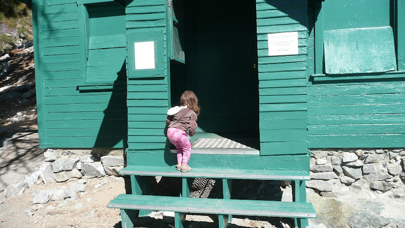
The front steps of the ski hut

Of course, one could simply just take in the view.
The view to the south from San Antonio Ski Hut

So, whether your pursuits are extreme or prosaic, the ski hut is nice destination in a lovely setting.
The enchanting environs of the ski hut

Well, that's it for today's journey; time to head for home.
Descending from the ski hut

I thank you for joining me on a trip to the San Antonio Ski Hut on the slopes of Mount Baldy.

HJ

Monday, October 8, 2012

Fall Color in Aspen Grove

UPDATE 16 July 2015:  Many (but not all!) areas in and around the San Gorgonio Wilderness are currently closed due to the Lake Fire.  See Lake Fire Closure Map for details.  Unfortunately, Aspen Grove did burn, so it will be some time before the trees described below once again show forth their glory.

Nature puts on for us a spectacular annual show, a show most commonly known as "fall."  Of course, Southern California "doesn't have seasons" (or so they say), so there's simply no point in going looking for any fall color -- or is there?

Well, interestingly enough, there's a lovely grove of quaking aspen (Populus tremuloides) in Southern California.  Yes, you heard that right, there are quaking aspen in Southern California.  And quaking aspen are famously colorful in the fall.
Quaking aspen (Populus tremuloides)  in Southern California
But how can this be?  Quaking aspen are more associated with cooler northern climes such as those found in the Colorado Rockies.

Well, the answer lies in geologic history.  In the last ice age, a cooler, moister climate prevailed here in Southern California.  Trees like the quaking aspen prospered.  After the ice age, the area grew warmer and drier, the aspens largely died out, but a small remnant grove of aspens was left behind in a sheltered spot along the banks of Fish Creek high in the San Gorgonio Wilderness, a spot now appropriately known as Aspen Grove.  Please join me as I take a brief look at this year's fall display.
Fall colors at Aspen Grove in Southern California
Or trip begins on unpaved Forest Road 1N05 where it leaves the better maintained and wider Forest Road 1N02 (also unpaved).
The turn off to Aspen Grove and Fish Creek
Don't worry, though.  Even though the road is unpaved and a bit rough, with a bit of care, the average passenger car can make it.  The sign says 7 miles (11km) to Fish Creek, but we're not headed that far.  We're only going to Aspen Grove Saddle which is about 1.25 miles (2km) from the road junction.  From there we'll hike about 10 or 15 minutes to the boundary of the San Gorgonio Wilderness and then perhaps another 20 minutes to get to the various stands of aspen.  This as you might surmise makes for good family hiking.

Note:  The San Gorgonio Wilderness is a federally designated wilderness area.  A wilderness permit is required for all day and overnight use.  Contact the Mill Creek Ranger Station to obtain a free permit.  See contact information in Appendix "A," below.
The well marked trailhead for Aspen Grove.  
Shortly after leaving the above noted road junction, we come to Aspen Grove Saddle, the location of our trailhead.  The hiking portion of our trip starts down the rutted remains of an old road.  The trail begins behind the "WELCOME" sign that you can see in the above photo.  After only a few minutes walk, we start seeing the brilliant colors of what we came to see:  quaking aspen in their fall plumage.
The brilliant colors of the quaking aspen stand in stark contrast to the surrounding forest
Soon thereafter, we come to Fish Creek, which marks the boundary of the San Gorgonio Wilderness.  Fortunately, Fish Creek runs low in fall, and presents little obstacle in terms of crossing.
Fish Creek at the crossing point en route to the aspens.   Easily crossed.
 Despite its low water level in fall, Fish Creek is still a picturesque spot.
Lovely Fish Creek, just above the crossing
On the far side of the creek, we enter the San Gorgonio Wilderness and come under the golden canopy of the aspens.
Entering the first stand of aspens
From the entry point to the wilderness, we have the choice of either turning left (south) or right (north). The majority of the aspens lie to the north, but a brief walk south takes us to this scenic, aspen-lined section of trail.
The Aspen Grove trail heading through the aspens.
For whatever reason, it seems that the best, most vivid colors lie to the north, but this section of Aspen Grove is well worth visiting.

Turning, we now head north.  We leave the dense stand of aspens at the entry point of the wilderness and head through more open forest with a mixture of aspens and conifers.
Heading through mixed, open forest en route to the more northern stands of aspen
This is comparatively gentle terrain, generally suitable for even young walkers.
Easy hiking in Aspen Grove
Heading further down the trail, we re-cross Fish Creek, ascend a slight rise and come to this:
A large, relatively pure stand of quaking aspen
The stand of aspen shown above is the largest and purest in the Aspen Grove area.  It is here that I've typically seen the most brilliant colors.
Fall gold in Aspen Grove
My experience is that late afternoon, when the sun backlights the trees from the west, is a good time for fall color viewing and photography.
Aspen aglow in the afternoon sun
Here, photographic opportunities abound.
Ripe fall gold
Take care though, not too come too late.  As the sun fades, so does the brilliance of the fall color.
Fall color in the late afternoon
But as long as the sun shines, the golden colors show forth.
Vivid late afternoon hues
I'm not much of a photographer, nor do I have anything more than a "point and shoot" camera, but I think a few of these photos came out quite nicely, which is more a tribute to the natural scenic beauty of Aspen Grove than to any photographic skill that I might have.
The shifting sun variously highlights the brilliant autumnal leaves
It's such a lovely sight that we stay as long as we can, but alas the sun finally sinks below the ridges of Grinnell Mountain to the west, and we lose our light.  Still, even in the fading light of evening, the aspens put on quite a display.
Aspens in the fading light of evening
It's now time to turn for home, but not before we take one last shot of autumnal gold.
A parting shot of fall's glory at Aspen Grove
The best time for viewing the colorful aspen leaves has been around the first weekend of October the last couple of years.  Indeed, the fall colors are at their height as I write this on October 8th.  Don't wait to go, the leaves drop to the ground quickly after the colors peak.  After all, why do you think they call it "fall?"

I hope you've enjoyed this brief look at the fall colors of Southern California.  I thank you for joining me,

HJ

Appendix "A" -- Contact Information

Mill Creek Ranger Station
34701 Mill Creek Rd.
Mentone, CA 92359
(909) 382-2882


Appendix "B" -- Personal Notes
This post of course is concerned primarily with the rich fall colors of Aspen Grove, but really Aspen Grove is a splendid family hike any time the weather is good and the road is open (check with the Mill Creek Ranger Station concerning road conditions).

The banks of the creek are shaded and are a perfect spot for a picnic or just "hanging out."
"Hanging out" at Aspen Grove
Aspen Grove is a great spot, well away from noisy highways, perfect for a relaxing afternoon.
Father-daughter time at Aspen Grove
In all, it's a really fun family outing.
Hammock time at Aspen Grove
Aspen Grove:  Highly recommended.