I was out on the Vivian Creek Trail this past weekend (5/28 - 5/30/2016). Here is a brief report of the conditions I encountered. The position of each item that I reference is plotted via GPS waypoints on this topographic map:
http://caltopo.com/m/5EDU. Mileages between points is noted. I will list my observations below using the waypoints on the map.
Of course there's lots of fun stuff that I didn't way point. Like these snow plants, a personal favorite of mine and evidently of my daughter as well.
 |
| Snow Plants near the Vivian Creek Trailhead |
141 - Mill Creek Crossing. Mill Creek is flowing with a small stream along the south bank at the point of crossing.
 |
Mill Creek.
Don't cross if it's flooded. A young man died here last year. Be patient. The water will recede. |
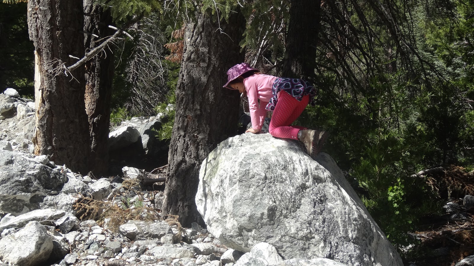
And of course there are lots of really fun rocks to climb in and around Mill Creek.
 |
| Bouldering on the margins of Mill Creek. |
165 - Both signs on the north side of Mill Creek got graffitied over the weekend.
On the way in:
 |
| Sign on N side of Mill Creek on Saturday on the way in. |
On the way out:
 |
| On Monday on the way out. |
 |
| Both signs got graffitied over the weekend. |
161 - 164 - Four rocks got graffitied.
 |
| Graffiti on rocks. Why? Why destroy nature? What did nature ever do to you? |
As we ascend, we get great views of rugged Yucaipa Ridge. Not much snow compared to a month ago.
 |
| Yucaipa Ridge |
Climbing higher, we come to the wilderness boundary sign, and the trail (finally!) starts to level off. For some reason I didn't way point this spot, but given that there's a big sign there, you're unlikely to need a GPS waypoint to find this spot.
 |
| Wilderness boundary sign on the Vivian Creek Trail. |
142 - Vivian Falls Overlook. Just past the boundary sign, look for a faint trail leading down and to the left. This leads to a little overlook from which you can see Vivian Falls.
 |
| Vivian Falls are flowing nicely, and the canyoneers are out in force. |
143 - Vivian Creek Camp. After passing the overlook, one enters the lovely forested area that hosts Vivian Creek Camp, one of the nicest trail camps in the San Gorgonio Wilderness. Oddly, I saw no tents here even though it was Memorial Day Weekend.
 |
| Sign pointing to Vivian Creek Camp |
In terms of greenery and scenery, Vivian Creek is definitely the most beautiful of the three camps along the Vivian Creek Trail.
 |
| Meadow and spring near Vivian Creek Trail Camp |
 |
| Near Vivian Creek Trail Camp. |
144 - Vivian Crossing. After passing Vivian Creek Camp, one crosses to the west bank of Vivian Creek. The point that the trail crosses is known as Vivian Crossing. Water was flowing reasonably well here but by no means high volume.
 |
| Vivian Crossing |
145 and 146. Three downed trees fairly close together.
 |
| First downed tree. Approx 30" diameter. |
 |
| First Downed Tree from the other side. You can squeeze through. |
 |
Second Downed tree. 24" diameter. Bypass on downhill side.
Bypass is destroying trail tread and causing erosion. |
 |
Third Down Tree. Lying directly on trail. Bypass on downhill side.
Bypass is causing some erosion. ~24" diameter. |
While fallen logs on the trail aren't much fun, fallen logs across the creek are another matter.
 |
| Crossing Vivian Creek on a large fallen log. |
148. Another downed tree. A small one.
 |
| Downed Tree. 8" diameter. Easy step over for most people. No erosion problems. Low priority. |
149 - Yet another downed tree. I forgot to take a photo of this one. No further info. Sorry. But it couldn't be too bad or I'd remember it.
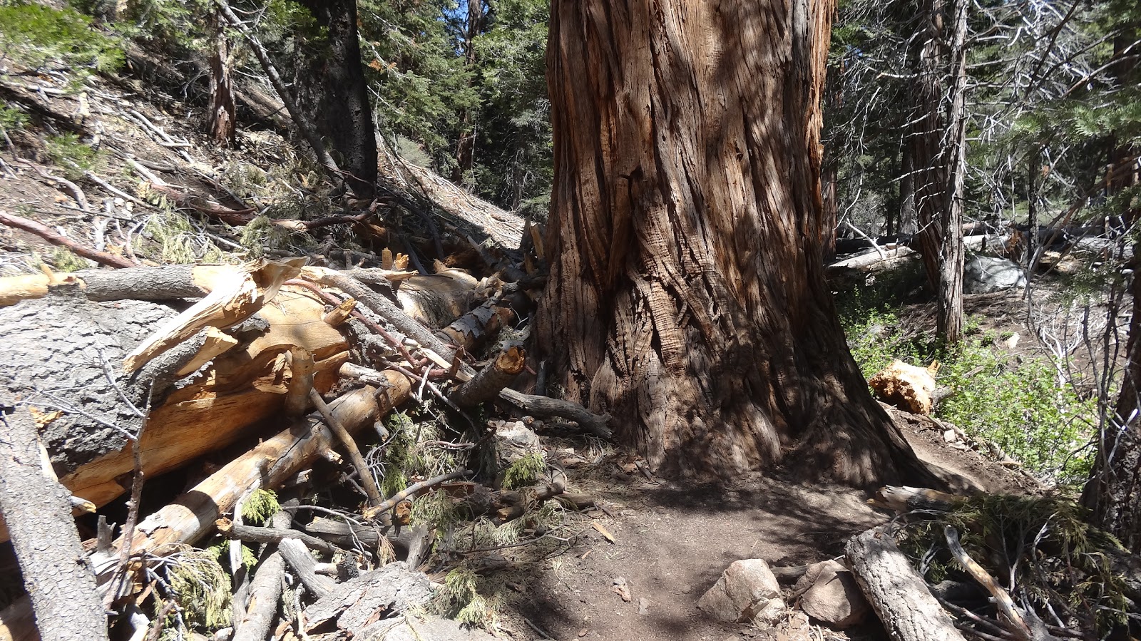
150 - A massive downed tree.
 |
| Massive downed tree. 40+ inch diameter. Bypass around left. No erosion caused. |
160 - Halfway Spring. Vivian Creek where the trail crosses the creek right before Halfway Camp is dry, but if you go 500 feet up the creek bed, you will encounter Halfway Spring. The flow is fairly low, but it is flowing.
 |
| Halfway Spring |
151 - Halfway Junction. Note that Halfway Junction is approximately halfway between Vivian Creek Camp and High Creek Camp. It is NOT halfway to the summit of San Gorgonio Mountain. It's roughly 10 miles each way to San Gorgonio Mountain. Halfway Camp is at mile 4. Yes, some out of date sources list the mileage as 8 miles each way to San Gorgonio Mountain. Um, no. It's a lot further than that. Maybe it's 9.5 miles instead of 10, but it certainly isn't 8 miles. You've still got about 6 miles to go when you reach this junction.
 |
Halfway Junction. Joycie points the way:
Right to Halfway Camp; Left to High Creek Camp and San Gorgonio Mountain. |
152 - Halfway Camp. A nice place, but unfortunately there are those who have no self respect and don't give a darn about nature or anyone else. Why they go out into the beauty of nature only to despoil it, I will never understand. I broke up three fire circles, and dug up three others that were just on open ground.
 |
Halfway is actually a pretty nice (and spacious) place to camp. Unfortunately, some people are scum bags.
On the other hand, there are some really nice people in this world. My neighbors at camp packed this junk out. |
 |
Illegal fire circle at Halfway Camp.
We lost half the wilderness last year when a fire got out of control. What are these people thinking!?
Unfortunately I couldn't break this one up; the rocks were too big and too embedded in the ground. |
153 - Another downed tree. This one is a serious impediment to travel. Two logs are stacked one atop another. You can bypass on the high side. The bypass is causing erosion.
 |
Top log about 30" diameter.
Bottom log about 20" diameter. |
Of course if you're small of stature, you can just go under it.
 |
When you're small, you just go under.
"Why can't you go under, daddy?" |
154 - Another downed tree. Directly across the trail. Not much option but to climb it. A bit of a challenge for those with a heavy overnight backpack.
 |
About 36" diameter.
Note Joycie bypassing the downed tree with her usual aplomb. Not recommended for adults. |
155 - Illegal campsite and fire circle. I removed the fire circle.
156 - a small washout, but it's going to get worse. The tread is narrow here if you look closely. Just trimming back the manzanita would help.
 |
| Small washout leaving the tread fairly narrow. |
157 - Junction with use trail to High Creek Falls.
 |
| The junction with the use trail to High Creek Falls is just past this dead snag. |
 |
| Plenty of water going over High Creek Falls |
 |
| High Creek Falls. |
It's a bit of a trick to get a good shot of High Creek Falls, but despite the poor quality of my photos, I assure you that it's worth the short trip down the side trail to visit. And there's a something of a nice view from the top of the falls.
 |
| Taking in the the view from the top of High Creek Falls |
If ever you have trouble finding water at High Creek Camp, just go into the stream bed immediately above the falls. Water is forced up by the bedrock. There's nearly always water here.
 |
| High Creek, just above High Creek Falls. Plenty of water. |
158 - E. Fork High Creek. Oddly, it is the E Fork of High Creek that typically has water even though the W Fork drains a larger area. It was flowing very nicely indeed on Memorial Day weekend. If the first drainage that you come to is dry, the one where the tent sites are, panic not. The next drainage to the east is where the water typically is. Even if the E Fork were dry, there should be water just above High Creek Falls.
 |
| E. Fork High Creek, 5/29/2016. |
159 - High Creek Camp. The camp area at High Creek is most known as a jumping off spot for assaults on San Gorgonio Mountain and for its good water supply. It's not nearly as nice as Vivian Creek Camp or Halfway Camp. It's a bit exposed, and it's quite rocky.
 |
| Tent site at High Creek Camp |
To only make matters worse, there are people who don't know how to use the bathroom in the woods. You need to bring a potty trowel or the equivalent and dig a hole 6 to 8 inches deep and bury all human solid waste in the hole. Pack out or bury your toilet paper. Putting a rock over your toilet paper is NOT burying it.
 |
| Improper disposal of toilet tissue. Toilet tissue should be buried 6 to 8" deep or packed out. Do NOT burn! |
You need to be at least 100 feet and preferably 200 feet away from creek beds -- even if they're dry at the time. Creek beds should not be used as a latrine! The next rain will flush all the human waste into the water supply. Wildlife can be decimated by human disease introduced through poor hygiene.
 |
| W Fork High Creek. Note toilet paper. People are using the creek bed as a latrine. |
Feminine products should be placed in a zip lock bag and packed out. They will not bio-degrade. Come back 50 or 100 years later, and they'll still be there.
 |
| Uh, just put it in a ziplock and pack it out, OK? I mean, how hard is it? If it's really gross, just double bag it. |
And here's our "loser of the week" entry: An illegal fire pit
and trash in an illegal camp site. And why, if you can pack in a water bottle that weighs 2 lbs when full, can't you pack out a bottle that weighs 1 oz now that it's empty? I just don't get it.
 |
| Illegal fire pit at an illegal camp site with trash dumped. You just won "loser of the week." |
I hate to be so negative, but really, why come to the wilderness just to trash it? What?
 |
| Trash collected and bagged. This is just what I carried out. Thank you to the other two groups that also packed out trash. |
 |
| I looked like a junk peddler with so much trash lashed to the back of my pack, lol. |
And lots more fire circles. All fires are illegal in the San Gorgonio Wilderness all the time, in all four seasons, all year round.
 |
| Before. The fire circle is over Joycie's left shoulder and is filled in with rocks (as if that would hide it). |
 |
| Clean up. Fortunately I have an assistant to help me dig up fire circles. |
There was a bit of snow across the switchbacks above High Creek. Nothing serious but some people were using that as an excuse to cut the trail. I had a small shovel along, so I cut some trail through the snow.
 |
| I cut some trail over a snow bank. Hopefully that makes travel a little easier. |
 |
| I also piled up a bunch of wood at the place where people were cutting the trail. |
I suspect that people who cut the trail probably have never done trail work. Trails are HARD WORK and cutting the trail can wipe out a trail. People who have done trail work know just how much effort is involved and I don't think they'll do destructive things.
But let's not focus on the negative. This is a great area, and there's fun things to do,
 |
| Bouldering near Halfway Camp |
and great scenery to view.
 |
| Yucaipa Ridge seen from hear High Creek Camp. |
There's my trip report for the Vivian Creek Trail. Hope it's instructive, and I hope I'm not too much of a downer harping on trash and stuff. Most people love the wilderness and work to preserve it. I'm sure the people who read a blog like this aren't the ones who try to trash the wilderness and light fires. Please, enjoy and care for the wilderness – and stay safe out there.
Thanks for joining me,
HJ